

Wondering what to see on the Icefields Parkway? Start here.
This 232 kilometre stretch of highway between Lake Louise and Jasper is packed with glaciers, waterfalls, and turquoise lakes, and choosing where to stop is half the fun.
From the ancient ice at the Columbia Icefield to the impossible blue of Peyto Lake, every pullout on this drive earns its place. Below are the stops our team recommends most, in the order you'll reach them heading north from Lake Louise.
You won't have time for all of them in one day. Use this list to build the stops that matter most to you.
135 km (84 miles) from Lake Louise
98 km (61 miles) from Jasper

The Glacier Sky Walk puts you on a glass floored platform 280 metres above the Sunwapta Valley. Getting there means a walk along the Discovery Trail first, and entry runs $25 per adult. If heights aren't your thing, the nearby lookout point gives you the same valley view with both feet on solid ground.
39 km (24 miles) from Lake Louise
194 km (121 miles) from Jasper

Bow Lake marks the headwaters of the Bow River, which flows south through Calgary on its way to Hudson Bay. Pull over here for a clear view of the Crowfoot Glacier, Wapta Icefield, Bow Glacier, Crowfoot Mountain, and Mount Thompson, all from one spot along the road.
44 km (27 miles) from Lake Louise
189 km (117 miles) from Jasper

Peyto Lake is the most photographed lake in the Canadian Rockies, and once you see the colour, you'll understand why. Glacial rock flour suspended in the water gives it that bright turquoise shade through the summer months. The best view is from Bow Summit, sitting at 2,088 metres, the highest point on the drive and the highest elevation reached by a public road anywhere in Canada.
79 km (49 miles) from Lake Louise
153 km (95 miles) from Jasper

Three rivers meet here: the North Saskatchewan, the Howse, and the Mistaya. The North Saskatchewan eventually travels over 1,600 kilometres east to Lake Winnipeg. "The Crossing" is also your starting point for Columbia Icefield tours and the only stop along this stretch with a gas station, public washrooms, and a restaurant, so plan your fuel and food stops accordingly.
106 km (66 miles) from Lake Louise
126 km (78 miles) from Jasper

At Cirrus Mountain, the Weeping Wall lives up to its name. Water cascades more than 100 metres down the cliff face in a series of falls, the largest of which is called Teardrop.
115 km (71 miles) from Lake Louise
118 km (73 miles) from Jasper

You'll know this stop when you feel it. The road descends along the mountainside and wraps through the Big Bend, a sharp hairpin turn with towering peaks on every side and sweeping views of the valley below. If you stop here, make sure your vehicle is completely clear of the road.
120 km (75 miles) from Lake Louise
112 km (70 miles) from Jasper

Parker Ridge rewards a bit of effort with one of the best views on the whole route. The hike takes about two hours and climbs 250 metres, ending with a look at the Saskatchewan Glacier, the longest in the area, along with several surrounding mountain ranges. Parks Canada closes this trail from late spring into early summer to let the landscape recover, so check conditions before you plan around it.
128 km (80 miles) from Lake Louise
104 km (65 miles) from Jasper

The Columbia Icefield stretches across Banff and Jasper National Parks and is the largest icefield south of the Arctic Circle, covering 325 square kilometres and reaching up to 365 metres deep. Snowcoach tours take you onto the glacier itself in summer, or you can take it in from the roadside parking lot. Stop at the Columbia Icefield Centre for a natural history museum, a three-dimensional model showing the icefield's three meltwater drainages, and exhibits on alpine wildlife and how glaciers form.
177 km (110 miles) from Lake Louise
56 km (35 miles) from Jasper

Sunwapta Falls drops about 18 metres through a narrow gorge just south of Jasper. Fed by the Athabasca Glacier, the falls run heaviest in late spring and early summer when snowmelt peaks.
200 km (124 miles) from Lake Louise
33 km (21 miles) from Jasper

Located 30 kilometres south of Jasper, Athabasca Falls is less about height and more about sheer power. The volume and force of water here make it one of the most memorable stops on the parkway, and several viewing platforms and trails let you get close safely.

There is no cell service along the parkway, so this free guide map is worth downloading before you head out. It covers key stops, distances, and everything you need to make the most of the drive.
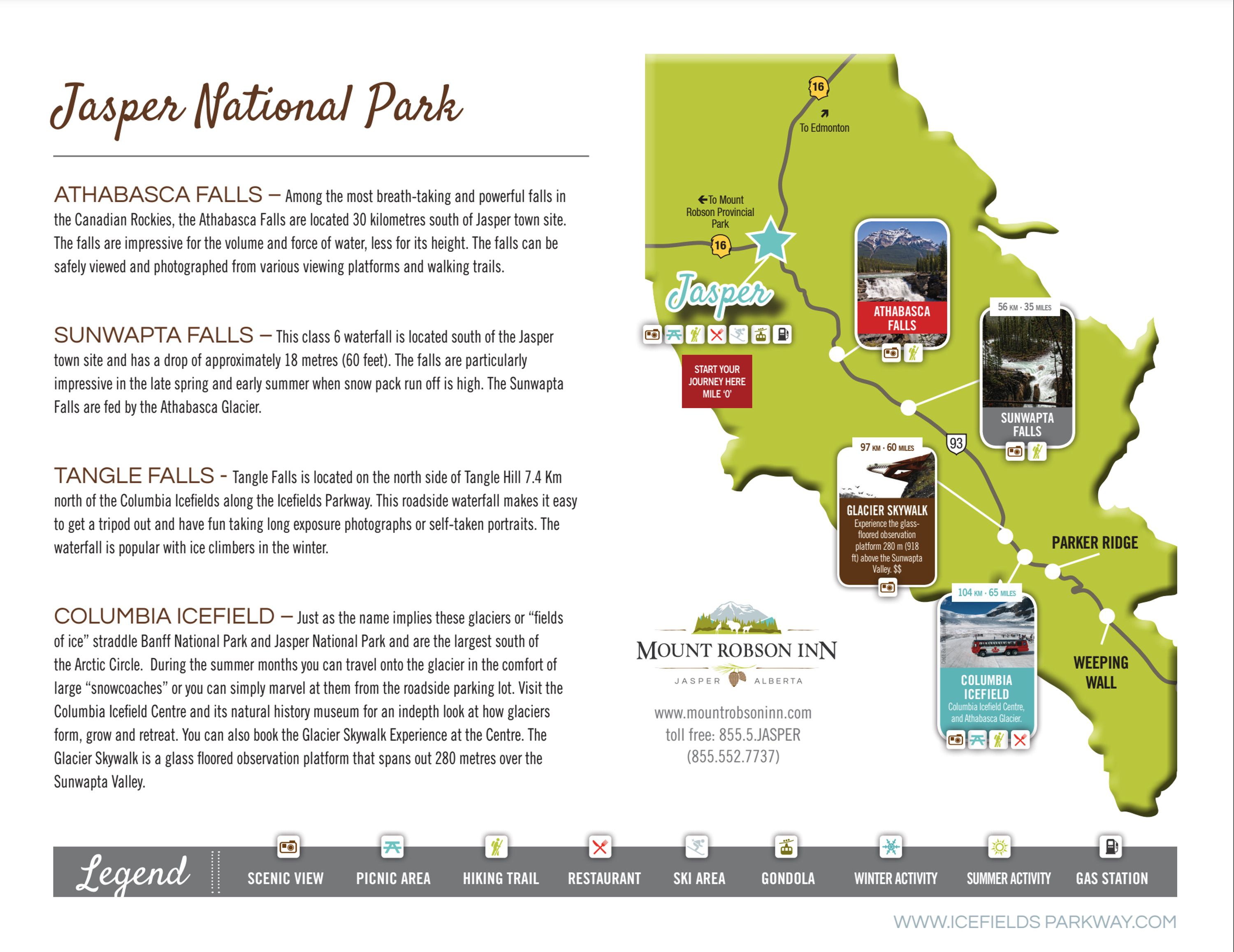
These top-rated hotel properties sit right at the parkway's access points in Lake Louise, Jasper and Valemount, so you can start your drive early, stop as often as you like, and never feel rushed to make it back before dark.
Get your Icefields Parkway Guide Map


